
Henry Hudson
1570(?) -1611(?)

Henry Hudson's first voyage
1607:
The Northern Passage
Last updated:
January 20, 2007
| Written &
researched by Ian Chadwick, Text & design copyright © 1992-2007 |
|
 |
Web design, Net training, writing, editing, freelance columns, editorial commentary, research & data analysis. |
Hudson's aim was to discover a sea route over the North Pole, or as the Company wrote, "to discover a passage by the North Pole to Japan and China." Hudson also wanted to reach the Spice Islands (Moluccas), in the Malay Archipelago, a source of trade and spices.
 Henry Hudson first appeared in written history as a captain of his own ship, the
Hopewell. In his first recorded voyage (the journal written jointly by
Hudson and crew member John Playse), he attempted to find a passage to the Orient
through the north across the pole. It was a theory of several geographers of his day that
- because of the constant sunshine - the Arctic actually got warmer the further north you went. They reasoned the sun would melt the ice at the poles, and if you sailed due north,
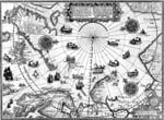
you'd eventually reach open water. Sadly, this was not the case. Click image
for a map of this voyage.
Henry Hudson first appeared in written history as a captain of his own ship, the
Hopewell. In his first recorded voyage (the journal written jointly by
Hudson and crew member John Playse), he attempted to find a passage to the Orient
through the north across the pole. It was a theory of several geographers of his day that
- because of the constant sunshine - the Arctic actually got warmer the further north you went. They reasoned the sun would melt the ice at the poles, and if you sailed due north,
you'd eventually reach open water. Sadly, this was not the case. Click image
for a map of this voyage.
Hudson must have earned his rank by serving on previous ships and probably worked his way up from cabin boy, learning navigation, cooking, handling sails, reading the weather and caring for a ship long before he had his own command. Also, as captain, Hudson had to keep a ship's log, so he must have been able to read and write (a rare talent in Elizabethan times).
Hudson's first ship was probably typical of the ships of his day: designed for short trips for trade along the European coasts, these ships were not well suited for long, dangerous journeys over unknown and dangerous oceans. Chaucer's lines, written more than two centuries earlier, "A little boat/No bigger than a man's thought," would still be appropriate for many late 16th and early 17th century ships.
While his voyage was unsuccessful in finding a route across the pole, Hudson did make several important discoveries. Prime among these were the pods of whales at Spitzbergen Island, which offered a significant commercial opportunity to English sailors. Hudson would become known as the grandfather of the English whaling industry. Hudson also sailed further north than any other explorer before him on this voyage.
 In this voyage Hudson
also amended the map of Edward Wright, published by Hakluyt in 1599 and 1600.
One historian. C. H. Coote, identifies this amended
map of Hudson's with the "new map" referred to by Shakespeare in his
play "Twelfth Night."
("...he does smile his/face into more lines than is in the new map/with the augmentation of the Indies..."
First performed in 1602, printed in the First Folio of 1623).
In this voyage Hudson
also amended the map of Edward Wright, published by Hakluyt in 1599 and 1600.
One historian. C. H. Coote, identifies this amended
map of Hudson's with the "new map" referred to by Shakespeare in his
play "Twelfth Night."
("...he does smile his/face into more lines than is in the new map/with the augmentation of the Indies..."
First performed in 1602, printed in the First Folio of 1623).
The English colony of Jamestown, Virginia, was founded in 1607 by John Smith. In 1607, the Dutch States-General created the West India Company for Dutch merchants who traded or buccaneered in the New World. It gave them the sole right of trading with the eastern coast of America from Newfoundland to the Straits of Magellan, with the whole Pacific coast and Africa from the tropic of Cancer to the Cape of Good Hope.
 Hudson's first command was the ship Hopewell (sometimes noted as
Hope-well or even Hopeful) for the Muscovy (Russia) Company in which his family had
shares.
Hudson's first command was the ship Hopewell (sometimes noted as
Hope-well or even Hopeful) for the Muscovy (Russia) Company in which his family had
shares. - The Hopewell was an aging, 40-ton (see notes) bark (barque), with a small crew. In 1606, John Knight had already sailed the Hopewell in search of the Northwest Passage along the coast of Labrador.
- Hudson's aim was to discover a sea route over the North Pole, or as the Company wrote, "to discover a passage by the North Pole to Japan and China." Hudson also wanted to reach the Spice Islands (Moluccas), in the Malay Archipelago, a source of trade and spices.
- Petrus (Peter) Plancius, a well-known Dutch geographer and Calvinist clergyman (originally named Peter Plantevoet, he was born in the village of Kemmel, in Flemish territory), believed the pole region grew suddenly milder and warmer thanks to five months of constant sunshine. Hudson agreed, and believed that by sailing north he would be able to navigate through open seas across the pole. This view was shared by Rev. Samuel Purchas of England, who never ventured more than 200 miles from his birthplace and used an idiosyncratic interpretation of Biblical scripture to give weight to his ideas.
- January: At a meeting of the directors of the Muscovy Company, Rev. Richard Hakluyt recommended Hudson as commander of the expedition, assuring the directors of the company that Hudson is qualified, saying, "He is an experienced seaman," and "He has in his possession secret information that will enable him to find the northeast passage." This is the first time Hudson's name appears in print.
- The 'secret information' was probably the 80-year-old pamphlet called Thorne's Plan, written by Robert Thorne, an agent of a prosperous Bristol trading company. His father had been a member of John Cabot's original crew. He had written a letter to Henry VIII suggesting a northeast route to Cathay, but when Henry showed little interest, Thorne had published the letter as a pamphlet in 1527. In it he wrote, "...there is no doubt, but sailing Northward and passing the Pole, descending to the Equinoctial line, we shall arrive at the Islands of Cathay, and it should be a much shorter way than any other." The pamphlet was reprinted in Hakluyt's Principal Navigations in 1598. The belief in a warm, ice-free North Pole was shared by Peter Plancius, the Dutch cartographer who would aid Hudson later in Amsterdam.
- Hudson visited Hakluyt in his Bristol home and examined charts in the latter's library. Hakluyt showed Hudson a letter to him by the Rev. Samuel Purchas, who also believed in a polar route, as well as both a northeast and a northwest passage. Purchas wrote of a possible voyage north, "...with how much ease, in how little time and expense the same might be effected..."
- Hudson argued with the factors of the company over the agreed fee of 100 pounds. He wanted more money and after haggling, they agree to pay him 130 pds. 5 shillings for his work.
- The company selected the Hopewell, a three-year-old, square-rigged 80-ton ship with three masts, for Hudson to command. She had already made six major voyages: two through the Baltic, and four to Portugal. She was a 'bark' (barque - a small sailing ship with three masts) with two principal masts and a smaller foremast. Barques were generally used as small merchant and coastal vessels, ranging from fully lateen rigged to square rigged ships. These ships usually did not exceed 300 tons, and sometimes had oars to propel them through poor winds or into the eye of the wind.
- According to Samuel Purchas, the first part of the ship's log was written by John Playse. On July 11, Hudson took over as author of the remainder of the log.
- Purchas felt the voyage over the North Pole would prove easy. He wrote that as sailors neared the pole, "that vast line at Circumference itself becomes (as the whole Earth to Heaven, and all earthly things to heavenly) no line any more, but a Point, but Nothing, but Vanitie."
April
 19: Hudson, his 16-year-old son John (possibly
only 14) and
ten crew members prayed at St. Ethelburga's church, near London Bridge, now one of the
oldest churches in London. The crew also included: William Collins (mate); James Young;
John Colman (bo'sun); John Cooke; James Beuberry; James Skrutton; John Pleyce (Playse);
Thomas Baxter (Barter); Richard Day; James Knight and John Hudson ("a boy").
19: Hudson, his 16-year-old son John (possibly
only 14) and
ten crew members prayed at St. Ethelburga's church, near London Bridge, now one of the
oldest churches in London. The crew also included: William Collins (mate); James Young;
John Colman (bo'sun); John Cooke; James Beuberry; James Skrutton; John Pleyce (Playse);
Thomas Baxter (Barter); Richard Day; James Knight and John Hudson ("a boy"). - 23: The Hopewell left London, but bad weather delayed them from getting much further for the first week. This event, recorded in Samuel Purchas' preface, is the first known written reference to Henry Hudson, the explorer.
May
- 1: Weather finally cleared, and the ship left Gravesend at the mouth of the Thames, heading for open water.
- 26: The Hopewell arrived at the Shetland Islands. Hudson sailed northwest instead of due north, which the company had directed him to do.
- 30: Crew noted the compass (magnetic) needle was deflected and believed the voyage was under an evil spell, and would soon meet with disaster. Hudson had to manage his crew carefully to avoid mutiny.
June
-
 13: After six weeks of sailing, they sighted the east coast of
Greenland
(now Kalaallit Nunaat), described in the journal as a "very high land for the most part
covered in snow, the remaining part bare."
13: After six weeks of sailing, they sighted the east coast of
Greenland
(now Kalaallit Nunaat), described in the journal as a "very high land for the most part
covered in snow, the remaining part bare." - Even today, these waters are considered treacherous to vessels - even today's modern steel-hulled ships with manganese-bronze propellers. Sailing Directions, published by the U.S Defense Mapping Agency notes the waters around southern Greenland as, "Notorious for foul weather and heavy seas... Dangerous rocks up to four leagues... Very strong mountain squalls... Winds from the southeast very strong gale strength..." Small, wooden ships like the Hopewell would have had to progress carefully, always watching for ice, rock and sudden shifts in weather. A little inattention could quickly result in disaster.
- Weather was bad, but Hudson spent two weeks mapping the previously unexplored coast. James Young was in the crow's nest and was the first to sight Greenland. In his honour, Hudson named Young's Cape.
- Early-mid June: Gales from the east brought freezing weather and snow. The ship hugged the Greenland coast while the rigging froze and, because of heavy fog, visibility dropped to zero. Hudson proceeded blindly ahead nonetheless.
- 20: The weather cleared and Hudson steered northeast, away from Greenland, aiming for 'Newland' (Spitzbergen, then called Svalbard, discovered by the Dutch in 1596).
 21: He reached 73° latitude N and named the land he sighted 'Hold With Hope'
(it was also part of Greenland). He wrote he wanted to see the northern end of Greenland which was
"unknown to any Christian."
21: He reached 73° latitude N and named the land he sighted 'Hold With Hope'
(it was also part of Greenland). He wrote he wanted to see the northern end of Greenland which was
"unknown to any Christian." - 25: The crew spied three 'grampus' swimming towards the ship. Sometimes identified as Risso's dolphin, it may have also been killer whales (Orca), the sighting of which which was considered a bad omen.
- 27: Ice continued to block the passage, and forced Hudson further northeast until the ship reached the western shores of West Spitzbergen Island near 'Vogel Hooke' (Bird Cape, discovered by Barents).
July
- 1: Hopewell arrived at a great inlet - "almost a bay" wrote Hudson.
- 6: The ship entered a "very green sea."
-
 8: Crew spotted many "sea-horses, or morses" - seals and walrus.
Walrus tusk would become a much-sought-after item for future traders.
8: Crew spotted many "sea-horses, or morses" - seals and walrus.
Walrus tusk would become a much-sought-after item for future traders. - 11: Henry Hudson took over writing the log from John Playse. There is no explanation why he didn't write it from the start nor why he took over at this point. Several of the crew were sick from eating unsalted bear meat the day before. The claim by Purchas of dual authorship of the journal has been challenged by later historians. Some suggest Playse copied it from Hudson's original.
- 12: "A sea setting us upon the ice has brought us close to danger," Hudson wrote. But a "small gale" saved them. At midnight, Collins spotted land to the south-southwest (Spitzbergen). Hudson inexplicably noted Collins as the boatswain in his entry, while he was entered as mate earlier, and noted Colman as the mate.
- 13: Hudson reached 80°23', about 577 nautical miles from the pole, but the way north was blocked by ice. The crew spotted many whales in the water. He named the land he saw, "Hakluyt's Headland."
- 14: Hudson reached North East Land, the northern island in the group.
 Hudson and
the crew found the northern tip of the island blooming in flowers, noting,
"Here we found it very hot." The crew went ashore and collected souvenirs
but were so warm they stopped to drink from a cool mountain stream. This may
have encouraged him in the belief the Pole got warmer as one travelled
towards it.
Hudson and
the crew found the northern tip of the island blooming in flowers, noting,
"Here we found it very hot." The crew went ashore and collected souvenirs
but were so warm they stopped to drink from a cool mountain stream. This may
have encouraged him in the belief the Pole got warmer as one travelled
towards it. - He stopped in what would later be called Whale Bay (now Collin's Bay, 750 miles north of the Arctic Circle) for the large pods of whales they found in the sheltered bay. One whale got caught in a fishing line but passed under the keel without harming the ship - although the hook and line were lost. Hudson calls the land Collin's Cape after the boatswain who first saw it. The crew explored the island, hunted game and found many whale bones and 'morse' teeth there. Hudson's reports would quickly spawn a new whaling industry in England and soon English whalers would ply these northern waters wreaking havoc on the whale population. The Dutch soon followed with their own whalers, and led the whaling industry well into the early 19th century.
- Hudson noted the midnight sun in his journal.
-
 15: Hopewell sailed northeast along the coast with "little wind and
reasonably warm" weather. To others, Hudson may have called this land the "Seven
Icebergs" although he didn't record it in his log.
15: Hopewell sailed northeast along the coast with "little wind and
reasonably warm" weather. To others, Hudson may have called this land the "Seven
Icebergs" although he didn't record it in his log. - 16: Surrounded by ice, Hudson attempted to get closer to the land ('Newland') they saw to the northeast but was blocked. Hudson wrote in his journal he believed there is no passage over the north pole. The land ahead of them, Hudson wrote, may extend as far north as 82° or perhaps "even further." However, he added, "this land may be profitable to those that will adventure it." The Hopewell headed back down the coast, southwest to Collin's Cape.
- 22: Hudson veered northwest again
- 23: At 80° 23' N. (Sir Martin Conway estimated this was really 79° 23' N, the mistake caused by Hudson's ignorance of the currents). This latitude was not exceeded until 1773 when Capt. Phipps reached 80° 48' N.
- 25: At 81° N.
- 27:
 Hopewell barely avoided a collision with a breakaway iceberg. Hudson managed to
escape by putting some crew in the boat and had them row hard to pull the ship out of its path just
in time. Hudson then headed southeast.
Hopewell barely avoided a collision with a breakaway iceberg. Hudson managed to
escape by putting some crew in the boat and had them row hard to pull the ship out of its path just
in time. Hudson then headed southeast. - 31: Realizing he had little good weather left for exploring, and unable to go
further north, Hudson finally decided to return to England.

August
- 1: Hudson noted the ship was opposite Cherie's Island, a rocky outcrop at 74 .30 N 19 E, discovered in 1596 by Willem Barents. Barents named the island "Bear Island," but it was named Cherie's Island by Stephen Bennet in 1603, when he thought he had discovered a new island. Sir Francis Cherie was one of the Muscovy Company backers who financed Bennet's expedition.
- On his return south, Hudson named a tiny, previously unnoticed island Hudson's Touches around 71°N. At this point he was roughly 400 miles off course. Hudson did not record this event in his own journal, but it is recorded by Captain Edge, also of the Muscovy Company, in Brief Discoverie of the Muscovia Merchants.
- It's difficult to understand why he hadn't simply sailed due south from Cherie's Island to the top of Norway. Instead he turned southwest until he was due north of the Faeroe Islands. Donald Johnson suggests he was planning to head west, winter over a Hold-with-Hope, and search for the Northwest Passage, or perhaps try again for a passage over the North Pole.
- Seven years later, Dutch explorers thinking they were the first to see it, called the island Jan Mayen Island, which it remains today. The island became a popular hunting site for walrus hunters, who killed the animals in great numbers, simply for their tusks, much as they killed the whales around Spitzbergen.
- 15: The Hopewell put in at the Faeroe Islands on its way home.
September
- 15: Hudson returned to Tilbury, England, after 3 1/2 months away.
- The company asked Hudson to lead a new whaling venture to the Spitzbergens, but he still believed there was a passage to the Orient through the northern waters to be found, so he declined. However, other English companies, as well as other nations, quickly reacted to his reports, sending whaling fleets to the islands Hudson had visited, and within a decade had decimated the gentle giant mammals. Without the whales, interest in Spitzbergen declined, and they were ignored for the next 400 years, until an international treaty gave them to Norway in 1920.
- During the winter that followed, Hudson dedicated himself to preparing for another voyage to the north.